An old map of the world and continents from 1635. An unusual cartographic curiosity from the archives of history. See a detailed 17th century map of the world by Dutch cartographer Willem Blaeu.
Map of the 17th century world
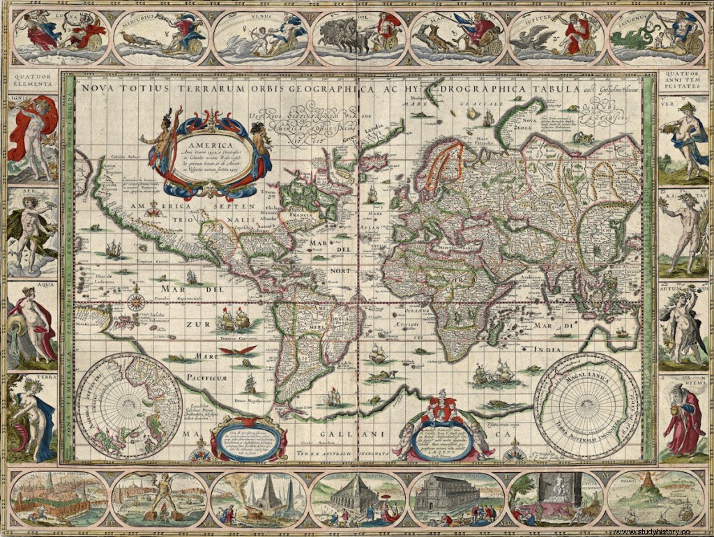
This remarkable old world map was compiled on the basis of the atlas of the famous Dutch cartographer Willem Blaeu. In his career, he has published many interesting items. The described map is entitled Nova Totius Terrarum orbis Geographica ac Hydrographica Tabula . The photocopy comes from the collection of the National Library of Norway. At the beginning of the 17th century, we are after the era of great geographical discoveries. The knowledge of the people of that time about the appearance of the world has significantly expanded, which can be seen on such archival maps as this one. The map is very detailed and we can read the names of many places.
Old world map from 1635 - Author:Willem Blaeu
The full resolution map (4500 × 3508) is available at this link.
A few words about the map
Note that the colored lines showing the boundaries between states and colonies may have been drawn much later. I wrote about it before, in the context of another map by the same author, where there are several versions of this map, but with differently marked borders. On this old world map, unlike the map of Europe, Poland and Lithuania are marked with original borders as one country. I believe that both Americas look particularly interesting, especially the North Americas with marked colonies. We see a picture of America, so different from what is recorded today.
On the website of the Library of Congress, I also found the same map, but in black and white. You can see it at this link. Here's a curiosity, the Library of Congress specifies the map's date as 1606. Perhaps this is the map's first release date. The Willem Blaeu map was one of the most popular maps in the 17th century, so there are probably quite a few versions and copies of it.
There are also additional graphics on the map. This time they were not cityscapes, as in the case of European maps, but 7 Wonders of the Ancient World.

One of the wonders of the ancient world - Colossus of Rhodes
Willem Blaeu is the author of many other interesting maps. I have described one of them before. This is an old map of Europe from 1644. You can see it in this article.
See also:Amazing Portuguese world map from 1502