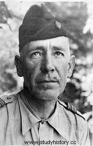
He is slender, knotty, of medium height, and between the cap and the pipe which rarely leaves his lips, the strong hooked nose betrays the man of character just as his gaze, sharp, attentive, the eye of a bird of prey, betrays the man of war. His name is Antoine-Marie-Pierre Charton, he is a lieutenant-colonel of infantry and a legionnaire. In October 1950, when this Jurassien from Poligny, Saint-Cyrien of the 1923-1925 "Chevalier Bayard" promotion, met his destiny, he was 47 years old. Since July 17, 1950, he has commanded the autonomous sub-sector of Cao Bang.
Cao Bang is a small town in the Upper Region of Tonkin, which during the Second World War and under the he Japanese occupation had four to five thousand inhabitants. It was then a smiling and picturesque city, covered with rosebushes and vegetable gardens, nestled on a peninsula at the confluence of two rivers, the Song Bang Giang, wide, deep and dangerous by its floods and the Song Hiem, more peaceful. .
Perched on a height overlooking the city, a citadel locks the peninsula. It was modernized at the start of the 1939-1945 war on the model of the Maginot line. Hundreds of meters of underground truffle its basement at a depth of 7 meters with its wells, its rest rooms, its infirmary and its ammunition depot.
Cao Bang is an important road and especially a key strategic node on the Chinese border. The city controls Colonial Route 4 – the famous R.C.4, soon universally known as the Road of Death – which runs along the Chinese border. The road leads south to DongKhé, That Khé, Langson and Moncay and northwest and west to Lao Kay and further to a still unknown basin called Dien Bien Phu.
For the past ten years, Cao Bang has no longer been the smiling city with the air of a southern sub-prefecture which served as the capital of the 2nd Military Territory.
The Japanese took the city in 1942. The Chinese invaded it in 1945. After the end of the Second World War, France recovered its former colonies. By withdrawing to make way for the French forces, the Chinese blew up the citadel. But with its undergrounds which are intact and its firing posts easy to repair, it remains formidable. Its lights effectively protect the airfield located outside the peninsula, on the left bank of the Song Bang Giang. Junkers and Dakotas put Cao Bang an hour by plane from Hafol.
By road, this connection takes several days. The R.C.4 follows the Sinotonkinoise border for 320 km. From Moncay to Tien Yen, it runs along the coast, then it sinks into the mountainous area of Day and Viet Bac. It is at Tien Yen that the supplies for the border area arrive by sea, the road convoys form at Khe Tu before taking the road to Cao Bang for a journey of 240 km, which lasts three days. The stopover lodges are located in Langson and That Khé. Remember these names.
From Langson to Cao Bang, the R.C.4 - don't imagine a wide paved road with two or four lanes:most often it's just a stony track not always 4 meters wide - is made up mostly of passes, defiles, bends, switchbacks, climbs, descents and tunnels, dominated by wooded heights covered with lush vegetation. Vehicles cannot overtake each other. The destruction carried out by the Viet-minh, in particular on the structures, requires diversions or extremely dangerous fordings.
It is in this context, both exotic and threatening that tragedy will unfold.
