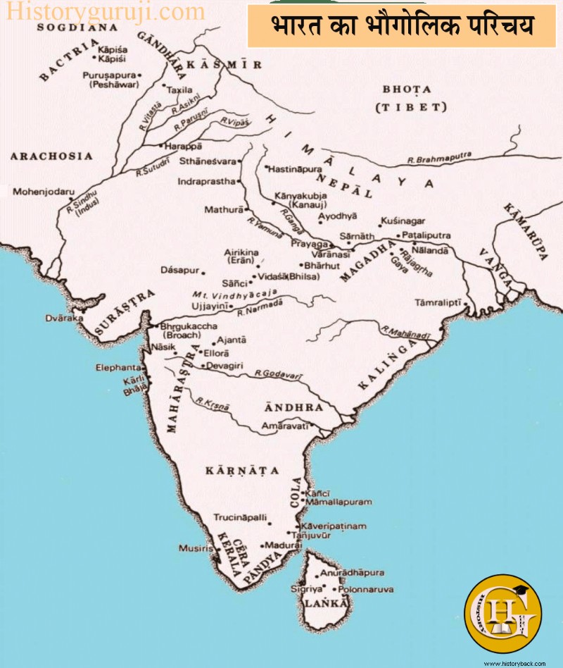
The Republic of India is the largest country in the Indian subcontinent, located in South Asia. The geographical extension of India, located entirely in the northern hemisphere, is 3,214 km from north to south. and 2,933 km from east to west. Is. India is the seventh largest geographically and second largest country in terms of population. The boundaries of the country are both natural and man-made.
Indira Kal in North-West in India But the country's terrestrial border meets Afghanistan, Pakistan, Tajikistan and China and Nepal, while the borders of China and Myanmar meet with the Indian border at the far north-eastern corner (Trisandhi). India's borders with Pakistan in the west and Bangladesh in the east are artificial or man-made, while India's borders with Afghanistan, Tajikistan, China, Nepal, Bhutan and Myanmar are natural. The international border between India and China is called 'McMahon Line' known as. India shares a maritime border with the Maldives in the Indian Ocean to the south-west, Sri Lanka to the south, and Thailand and Indonesia to the south-east. Its southernmost point 'Indira Point The Andaman and Nicobar Islands are located in the archipelago and Lakshadweep in the Arabian Sea is an insular part of India.
naming
The largest country in the Indian subcontinent, India is considered an eternal nation because it is the first nation to human-civilize. It has two official names - 'Bharat' in Hindi and 'India' in English. It is said in the Puranas that-
Varsh Yad Bharatam Naam Yatroyam Bharti Praja.
Means 'The land north of the sea and south of the Himalayas is named Bharat and its subjects are Bharati.' The country was named Bharat. Probably one of the prominent people of Rigveda name of famous person 'Bharat' This area 'Bharat It was called Janapada and the river flowing in its north-west was given the name Sindhu. Due to being the abode of the people of Bharata, it is also called 'Bharatvarsha ' where did it go. According to Jain tradition, this country was called Bharat in the name of Bharat, the eldest son of the first Jain Tirthankar Rishabhdev. 'India The origin of the name 'Indus is the English name of the river Indus. ' from.
Greeks named the Indus River as Indus and the country where this river flows as 'India'. The Iranians called the river Indus 'Hindu' and this country as 'Hindustan', which means 'Land of the Hindus'. Initially this name was less and more often used for northern India. Later this name became more popular, especially in Arab-Iran. The name was first used in India probably in the Vijayanagara Empire. Apart from this, Bharatvarsha has also been known by the names of Ajnabhavarsha, Aryavarta, Jambudweep etc.
The description of the establishment of the nation of India comes in the fifth canto of Shrimad Bhagavatam. According to Indian philosophy, after the creation of the universe, the Manas son of Brahma, Swayambhu Manu took over the system. In the Matsya Purana, Manu has been called 'Bharat' and this country as 'Bharat' by giving birth and feeding the subjects. Atharvaveda K's 'Prithvi Sukta ’ It has also been described as the homeland of Manu and progeny. He had two sons - Priyavrata and Uttanapada. Uttanapada was the father of Bhakta Dhruva.
Priyavrata had ten sons, three of whom were separated in childhood. Priyavrata divided the earth into seven parts and handed over one part (island) to each son for his remaining seven sons. One of these sons was Agnidhra, who was entrusted with the administration of Jambudweep. In old age, Agnidhra entrusted his nine sons with the responsibility of governing the various nine places (varshas) of Jambudvipa. The eldest of these nine sons was Nabhi, who got the land of the snow year. He associated Himvarsha with his own name Ajnabha as 'Ajnabhavarsh ' Promoted. This Himvarsha or Ajnabhavarsha was the ancient Bharatvarsha itself. King Nabhi had a son- Rishabh. Bharata was the eldest and most virtuous among the hundred sons of Rishabhdev. Rishabhdev handed over the kingdom to Bharata after taking Vanaprastha. Ajnabhakhand is called 'Bharatvarsha in the name of this Bharat. ’ began to be said.
The ancient literature of India shows that the whole of Bharat Khand was divided into five parts. Madhya Pradesh was between the Indus and the Ganges. According to Brahmanical texts, this land was extended from Saraswati river to Prayag, Kashi and according to Buddhist texts to Rajmahal. The western part of this region 'Brahmarshi Desh ' It was called. Patanjali called this whole land 'Aryavarta ' Said. In Manusmriti, Aryavarta has been described as the land situated between the eastern and western seas, northern Himalayas and southern Vindhyachal. 'Uttarapath in the north of Madhyadesh ' (Udchya), in the West 'Aparant ' (Pratichhya), in the south 'Dakshinapath ' (South) and East 'Oriental ’ (Prachi) was. In the far south was Tamiladesha or Tamilakam. In fact, from the geographical point of view, the land of India was from Kashmir to the border of Lanka and from Kashmir to Assam.
Geological structure
Geologically, India lies entirely on top of the Indian Plate, which is a subdivision of the Indo-Australian Plate. In ancient times this plate was part of Gondwanaland and was associated with Africa and Antarctica. About 90 million years ago in the Cretaceous period, this plate was 15 cm long. It started moving north at an annual rate and collided with the Eurasian Plate in the Eocene Period. The Tibet Plateau and the Himalaya Mountains were formed by the uplift of sediments of the Tethys geodesic between the Indian Plate and the Eurasian Plate. Later, due to the accumulation of depression in the front basin, the Indus-Gangetic plain was formed. The Indian plate is still about 5 cm. It is moving north at the rate of every year and still 2 mm in the height of the Himalayas. It is getting uplifted at the rate of every year.
Sources of Ancient Indian History
Geographical pattern
Materially the vast region of India is quite diverse. Almost all types of landforms are found in its geographical structure. On the one hand, there are huge and high Himalayan ranges in its north, and on the other hand there is the vast Indian Ocean in the south. On one side is the high and low and eroded Deccan plateau, while on the other side there is also the vast and flat Indus-Ganga-Brahmaputra plain.
While various desert landforms are found in the wide desert of Thar, on the other hand there are also coastal parts. In this peninsula there are many big rivers like Indus, Narmada, Brahmaputra, Ganga, Yamuna, Godavari, Kaveri, Krishna, Chambal, Sutlej, Beas. The Tropic of Cancer passes almost through it and almost every type of climate is found here. Similar geographical diversity is also in terms of soil, vegetation and natural resources. India can be mainly classified into four natural or physical parts-
1. The mountainous part of the Himalayas, 2. The Great Plains of the North, 3. The Peninsular Plateau Part 4. The Coastal Plains 5. The Island Parts.
The mountainous part of the Himalayas
The Himalaya Mountains are located in the north of India, hence it is also called the Himalaya Mountains. The Himalayan ranges are made up of new and twisted mountains. This mountain range extends from Kashmir to Arunachal in the shape of an arc on the northern boundary. From the physical point of view, four parallel ranges are found in the Himalayas, in which the Trans or Tibet Himalayas are located in the north, the Greater or Inner Himalayas, the Lesser or Middle Himalayas and the Sub or Shivalik ranges are located respectively in its south.
The Trans or Tibet Himalaya range is located to the north. It was discovered by Swain in 1906. Complete absence of vegetation is found on this range. The Greater or Inner Himalaya is the most prominent of the Himalayan ranges and the highest range in the world, which stands like a formidable wall from Nangaparbat in Kashmir to Assam.
The highest mountain peaks of the world are found in this range, among which Mount Everest (8,848 m), Kangchenjunga (8,598 m) etc. are prominent. The Lesser or Middle Himalaya ranges run parallel to the Greater Himalayas south of it. There are many fertile valleys between the Greater Himalayas and the Central Himalayas, in which the Valley of Kashmir and the Valley of Kathmandu in Nepal are particularly important. In the lower part of the middle Himalayas, the famous Shailavas of India are Shimla, Mussoorie, Nainital, Chakrata, Ranikhet, Darjeeling etc. The outer Himalaya or Shivalik range extends from the Potwar plateau of Pakistan to the Kosi river in the east. Many valleys are found between the smaller and outer Himalayas, which are called 'Dun' in the west and 'Dwar' in the east. Dehradun and Haridwar are prime examples.
The high ranges of the Himalayas can be crossed only in a few places where there are passes. These passes have special significance. To the north-west are the Khyber and Bolan passes which are now in Pakistan. India has made a new route from Pathankot to Srinagar via Banihal Pass. The way from Srinagar to Leh is through the Zojila Pass.
Vast Plain of North
To the south of the Himalayas and to the north of the Peninsular Plateau, composed of ancient rocks, is a broad flat plain that covers almost all of northern India. This vast arched plain has been formed by the deposition of alluvial soil deposited by the Indus, Ganga, Brahmaputra and their tributaries. This plain is also called 'Indus-Gangetic Brahmaputra Plain'. There is no mountain anywhere in this plain. The land is flat and gradually rises from the sea surface to the west. From the regional point of view, it is spread in North Rajasthan, Punjab, Haryana, Uttar Pradesh, Bihar, West Bengal, Orissa and Assam.
In the foothills of the Himalayas (Shivaliks) where the rivers leave the mountainous region and enter the plain, a narrow belt of pebble-stone mixed deposits is found in which the rivers intersect . This sloping area is called 'Bhabhar'. This is also the northernmost boundary of the Ganges plain. To the south of Bhabar is the Terai region, where extinct rivers reappear. These are actually low flat plains, which are filled with swamps and forests due to the spread of the waters of the rivers.
The alluvial plain is found in the south of the Terai. There are two types of alluvium in the plain, the old alluvial which is called 'Bangar' and the new alluvial which is called 'Khadar'. The Bangar area is made up of old alluvial soil, where the water of the floods of the rivers does not reach. Due to the abundance of limestone deposits in this area, it is not very suitable for agriculture. Khadar area is formed by new alluvial soil because new soil reaches here every year along with flood water. This area is more suitable for agriculture. Somewhere in the southern part of the plain there are small hills emanating from the southern plateau, such as the hills of Gaya and Rajgiri (Rajgriha) in Bihar.
Peninsular Plateau
The entire south of the North Indian Plain is a broad plateau that remains of the oldest land section in the world. It is mainly composed of hard and granular metamorphic rocks. The region is separated from the Indus and Ganges plains due to a range of mountain ranges and hills ranging in height from 460 to 1,220 meters. The plateau is surrounded by hill ranges on three sides. Rivers like Narmada, Tapti, Mahanadi, Godavari etc. have divided this region into many small plateaus.
In the north-west between the Vindhyachal Range and the Aravalli Range lies the Malwa Plateau which is formed by lava. To the north-east lies the Chota Nagpur Plateau, where the Rajmahal Hill forms the north-eastern boundary of the Peninsular Plateau. The Shillong plateau of Assam is also a part of the peninsular plateau which is separated by the Gangetic plain. Except Narmada and Tapti, all other rivers drain eastwards into the Bay of Bengal.
The western side of the peninsula has hills called the Western Ghats and the eastern edge is the Eastern Ghats. The Western Ghats are higher than the Eastern Ghats. The Eastern Ghats are not only low, but the rivers flowing into the Bay of Bengal – Mahanadi, Godavari, Krishna and Kaveri have cut it off at many places. In the south the Eastern and Western Ghats join the Nilgiri hills. South of the Nilgiris are the Annamalai and Cardamom (cardamom) hills. Between these hills and the Nilgiris is the Palghat Pass. Thalghat and Bhorghat are two important passes near Bombay in the Western Ghats.
समुद्रतटीय मैदान (Coastal Plain)
दक्षिण के प्रायद्वीपीय पठारी भाग के दोनों ओर पूर्वी घाट तथा पश्चिमी घाट पर्वतमालाओं एवं सागर-तट के बीच समुद्रतटीय मैदानों का विस्तार है। इन्हें पश्चिमी तथा पूर्वी तटीय मैदानों में विभाजित किया गया है। पश्चिमी तटीय मैदान संकीर्ण हैं, इसके उत्तरी भाग को कोंकण तट और दक्षिणी भाग को मालाबार तट कहते हैं। इस मैदान का विस्तार गुजरात में कच्छ की खाड़ी से लेकर कुमारी अंतरीप तक पाया जाता है। इस मैदान कोढाल पश्चिम की ओर अत्यधिक तीव्र है, जिस पर तीव्रगामी एवं छोटी नदियाँ प्रवाहित होती हैं।
पूर्वी तटीय मैदान अपेक्षाकृत चैड़ा है और उत्तर में पश्चिम बंगाल, उड़ीसा से लेकर दक्षिण में कुमारी अंतरीप तक फैला हुआ है। इस मैदान पर प्रवाहित होनेवाली नदियों- महानदी, गोदावरी, कृष्णा, कावेरी आदि ने विस्तृत डेल्टा का निर्माण किया है। इस पर चिल्का तथा पुलीकट जैसी विस्तृत लैगून झीलें भी पाई जाती हैं। मैदान का उत्तरी भाग उत्तरी सरकार तट कहलाता है तथा दक्षिण भाग को कोरोमंडल तट के नाम से जाना जाता है।
द्वीपीय भाग (Island Portion)
भारत के द्वीपीय भागों में अरब सागर में लक्षद्वीप और बंगाल की खाड़ी में अंडमान निकोबार द्वीपसमूह हैं। लक्षद्वीप प्रवाल-भित्तिजन्य द्वीप हैं या एटाल हैं, वहीं अंडमान निकोबार द्वीपसमूह अरकान योमा का समुद्र में प्रक्षिप्त हिस्सा माने जाते हैं जो वस्तुतः समुद्र में डूबी हुई पर्वत श्रेणी हैं। अंडमान निकोबार द्वीपसमूह पर ज्वालामुखी क्रिया के अवशेष भी दिखाई पड़ते हैं। इसके पश्चिम में बैरन द्वीप भारत का इकलौता सक्रिय ज्वालामुखी है।
भारत में प्रागैतिहासिक संस्कृतियाँ :पुरा पाषाण काल (Prehistoric Cultures in India :The Paleolithic Period)
भारतीय भूगोल का इतिहास पर प्रभाव (Impact of Indian Geography on History)
प्रत्येक देश का भूगोल उसके इतिहास को प्रभावित करता है और भारतीय इतिहास पर भी यहाँ के भूगोल का गहरा प्रभाव पड़ा है। भारत को प्रकृति ने एक दुर्ग के समान बनाया है। उत्तर में विशाल एवं अजेय हिमालय, दक्षिण में हिंद महासागर, पूर्व में बंगाल की खाड़ी तथा म्यांमार की पहाडि़याँ एवं पश्चिम में अरब सागर इसकी सीमाओं के रक्षक हैं। चारों ओर से प्राकृतिक सीमाओं से घिरा हुआ देश भारत अपनी संस्कृति की रक्षा करने में सफल रहा है।
भौगोलिक विविधताओं के कारण भारत में अनेक प्रकार की भिन्नताएँ पाई जाती हैं। भारत के विभिन्न क्षेत्रों में कद, रंग तथा बनावट के लोगों का पाया जाना क्षेत्रीय भिन्नताओं का ही परिणाम है। विभिन्न क्षेत्रों में विभिन्न प्रकार की जलवायु होने के कारण यहाँ विभिन्न प्रकार की वनस्पति, जीव-जंतु और रीति-रिवाज, खान-पान व संस्कृति देखने को मिलती है। यहाँ जलवायु व सुविधा के अनुकूल विभिन्न प्रकार के व्यवसाय पनपते रहे हैं।
प्राकृतिक विविधता के साथ-साथ यहाँ सामाजिक व धार्मिक भिन्नता भी दृष्टिगत होती है। भारत में सैकड़ों (222) भाषाएँ और बोलियाँ (545) हैं। वर्तमान में भारत के संविधान द्वारा 22 भाषाओं- हिंदी, बांग्ला, पंजाबी, गुजराती, मराठी, उडि़या, उर्दू, सिंधुी, असमिया, कश्मीरी, तमिल, तेलुगु, कन्नड़, मलयालम, कोंकणी, मणिपुरी, नेपाली, संस्कृत, डोगरी, संथाली, बोडो व मैथिली को मान्यता प्रदान की गई है।
भारत के विभिन्न भागों में अलग-अलग धर्म जैसे- हिंदू, मुस्लिम, सिख, ईसाई, बौद्ध, पारसी तथा जैन धर्म के अनुयायी रहते हैं। इन विभिन्न धर्मों तथा मतों के अनुयायियों में भी धार्मिक विविधता दिखाई देती है। इन्हीं क्षेत्रीय विभिन्नताओं के कारण देश में बहुत काल तक राष्ट्रीयता की भावनाओं का विकास नहीं हो सका। आज भी संस्कृति, भाषा, धर्म, प्रदेश, क्षेत्र, जल आदि को लेकर देश को विभिन्न सामाजिक समस्याओं का सामना करना पड़ रहा है।
भौगोलिक एवं सामाजिक परिस्थितियों की विभिन्नता के कारण भारत विश्व का एक लघु रूप बन गया। स्थानीय विशिष्टताओं के कारण भारतीय सभ्यताएँ युगों-युगों तक अपने स्वतंत्र रूप में विकसित होती रही हैं। भारतीय प्रायद्वीप की विशालता और भौगोलिक पृथकता के कारण ही संपूर्ण देश में कभी राजनैतिक एकता की स्थापना नहीं हो सकी, यद्यपि इसके लिए कई महान् शासक प्रयत्नशील रहे। यही कारण है कि भारत का इतिहास एक प्रकार से केंद्रीयकरण तथा विकेंद्रीयकरण की प्रवृत्तियों के बीच निरंतर संघर्ष की गाथा है। एक अलग विशिष्ट भौगोलिक इकाई होने के कारण चोलों को छोड़कर अन्य किसी भारतीय शासक ने इस प्रायद्वीप के बाहर साम्राज्य स्थापित करने का प्रयास नहीं किया।
भौगोलिक दृष्टि से भारत विविधताओं का देश है, फिर भी सांस्कृतिक रूप से एक इकाई के रूप में इसका अस्तित्व प्राचीनकाल से बना हुआ है, जिसमें अनेक सांस्कृतिक उपधाराएँ विकसित होकर पल्लवित और पुष्पित हुई हैं। हिमालय संपूर्ण देश के गौरव का प्रतीक रहा है, तो गंगा-यमुना और नर्मदा जैसी नदियों की स्तुति यहाँ के लोग प्राचीनकाल से करते आ रहे हैं। राम, कृष्ण और शिव की आराधना यहाँ सदियों से की जाती रही है।
उत्तर से दक्षिण और पूर्व से पश्चिम तक संपूर्ण भारत में जन्म, विवाह और मृत्यु के संस्कार एक समान प्रचलित हैं। भाषाओं की विविधता अवश्य है, फिर भी संगीत, नृत्य और नाट्य के मौलिक स्वरूपों में आश्चर्यजनक समानता है। संगीत के सात स्वर और नृत्य के त्रिताल संपूर्ण भारत में समान रूप से प्रचलित हैं। यह प्रायद्वीप अनेक धर्मों, संप्रदायों, मतों और पृथक् आस्थाओं एवं विश्वासों का महादेश है, तथापि इसका सांस्कृतिक समुच्चय और अनेकता में एकता का स्वरूप संसार के अन्य देशों के लिए विस्मय का विषय रहा है।
भारतीय संस्कृति विश्व की सर्वाधिक प्राचीन एवं समृद्ध संस्कृति है। मध्य प्रदेश के भीमबेठका में पाये गये शैलचित्र, नर्मदा घाटी में की गई खुदाई तथा कुछ अन्य नृवंशीय एवं पुरातात्त्विक प्रमाणों से यह सिद्ध हो चुका है कि भारत-भूमि आदि मानव की प्राचीनतम् कर्मभूमि रही है और आज से लगभग पाँच हजार वर्ष पहले भारत के सिंधु घाटी क्षेत्र में एक उच्चकोटि की नगरीय सभ्यता का विकास हो चुका था।
बौद्ध काल में भारत के सोलह महाजनपदों और उनकी राजधानियों का प्रमुख नगरों के रूप में उल्लेख मिलता है। दक्षिण भारत के कई नगर चेर, चोल और पांड्य राजाओं द्वारा बसाये गये जो कला, संस्कृति और व्यापार के समृद्ध केंद्र थे। प्राचीनकाल के भारतवासी केवल अपने देश की भौगोलिक सीमाओं तक ही सीमित नहीं थे, वरन् उन्हें विदेशों का भी ज्ञान था, जहाँ पर उन्होंने अपने व्यापारिक, राजनीतिक तथा सांस्कृतिक केंद्रों की स्थापना की थी। भारत से बाहर भारतीयों ने विस्तृत भूखंड में अपने उपनिवेशों की स्थापना कर सांस्कृतिक व व्यापारिक संबंध स्थापित किये, जिससे भारतीय सभ्यता एवं संस्कृति का बृहत्तर भारत में प्रचार-प्रसार हुआ।
अन्य देशों की संस्कृतियाँ तो समय की धारा के साथ-साथ नष्ट होती रही हैं, किंतु भारतीय संस्कृति आदिकाल से अपने परंपरागत अस्तित्व के साथ अजर-अमर बनी हुई है। प्रारंभ से ही भारतीय संस्कृति अत्यंत उदात्त, समन्वयवादी, सशक्त एवं जीवंत रही है, जिसमें जीवन के प्रति वैज्ञानिक दृष्टिकोण तथा आध्यात्मिक प्रवृत्ति का अद्भुत समन्वय रहा है।
मानवता के सिद्धांतों पर आधारित होने के कारण ही यह संस्कृति अपने अस्तित्व को सुरक्षित रख सकी है। इसकी उदारता तथा समन्वयवादी गुणों ने अन्य संस्कृतियों के उन्नत तत्त्वों को अपने में समाहित तो किया है, किंतु अपने अस्तित्व के मूल को सुरक्षित रखा है। यह भारतीय संस्कृति की सहिष्णुता, उदारता एवं ग्रहणशीलता ही है जिसके कारण बाहर से आनेवाले आर्य, ईरानी, यूनानी, शक, कुषाण एवं हूण जैसी प्रजातियों के लोग यहीं की माटी में घुल-मिल गये और अपनी पहचान खो बैठे। इससे लगता है कि यह प्रायद्वीप विदेशी तत्त्वों को आत्मसात् कर अपनी संपन्नता बढ़ाने की क्षमता रखता है।
यद्यपि भारतीय संस्कृति लोकहित और विश्व-कल्याण के कालजयी सिद्धांतों पर आधारित रही है, किंतु समाज को संगठित रखने के लिए निर्मित वर्ण-व्यवस्था में ऊँच-नीच और अस्पृश्यता, धर्मांधता, अंधविश्वास एवं सामाजिक रूढि़यों के प्रवेश के कारण इस संस्कृति का वास्तविक स्वरूप बहुत कुछ धूमिल-सा हो गया है।
अगर आपको हमारा यह आलेख ‘भारत का भौगोलिक परिचय’ पसंद आया हो तो इसको लाइक और शेयर जरूर करें। अगर कोई सुझाव हो, तो कमेंट अवश्य करें।
भारत में प्रागैतिहासिक संस्कृतियाँ :पुरा पाषाण काल (Prehistoric Cultures in India :The Paleolithic Period)
सिंधुघाटी की सभ्यता (Indus Valley Civilization)