On May 2 of this year, a total of 39 districts from the different provinces of the Puno region celebrate their 160 years of political creation through Legislative Decree No. 12103 approved by the transitory president of Peru, Mr. Ramón Castilla y Marquesado , evoking the combat of May 2 and the hero José Gálvez Ugúsquiza. One of the districts of the province of Puno is Atuncolla considered "The archaeological and tourist jewel of the Altiplano".
Geographical Location The district of Atuncolla is located west of Lake Titicaca at a distance of 30 km. approximately from the city of Puno, politically it is one of the 15 districts of the province and region of Puno. It is located at 3822 m. of altitude, in the natural region of Suni. Following the Qolla political-administrative division, the district is divided into two sectors or partialities:Hanansaya, which consists of 15 communities, and Hurinsaya, made up of 12 communities, hathas or ayllus. To the north it limits with the district of Caracoto, to the south with the district of Tiquillaca and Paucarcolla, to the east with the district of Huata and Paucarcolla, and to the west with the districts of Vilque and Cabana.
First settlers of Atuncolla Archaeological investigations indicate that the first human groups that arrived in Puno territory were 10,000 B.C. with an elementary culture, that is, nomadic collectors, hunters and fishermen who, following the course of the rivers, settled in caves or caverns where they left their cultural samples, the cave paintings. These primitive settlers had stone as their main instrument, dressed in animal skins and were grouped in bands or hordes led by the most capable. of more duration since the arrival of the first inhabitants to the altiplano (Palao; 2005:12). It is characterized by mainly nomadic populations of collectors and hunters, by low population densities; and by a dependency on lake and non-domestic flora and fauna.
The Kolla lordship The Kolla lordship had a large population and an extensive territory. It was located to the north-west of Lake Titicaca or Puquinacocha, according to the altiplanic cosmovision it was divided into two large sectors, Urcosuyo and Omasuyo; these in turn were divided into ayllus or Hathas. The Kollas included the provinces of San Román, Lampa, Azángaro, Huancané and Ayaviri in the Peruvian region of Puno. Carabuco, Ancorraimes and Huangasco in the current territories of the Republic of Bolivia. The capital city of the Kollas was probably Ullagachi. The Kolla state or kingdom, according to the memorial of the caciques of Huancané (1583), was made up of different nations or ethnic groups such as Caminaca, Achaya, Taraco and other peoples. Likewise, within the Kolla territory, the presence of two nationalities was evident:The Puquinaso Collas and Aymara, in approximately comparable numbers; but where, the former had power and political control. The puquinas formed the relicts of the ancient native population of the region, forgers of the most important cultures of the high plateau region such as Pukara, Tiahuanaco and Kollas. Only with the annexation of Kolla, to the empire of the Incas, was the introduction of huge groups of Mitmas from other nationalities, including Quechua-speaking kingdoms.
This is because in the ayllus of the Kolla kingdom several languages were spoken:in the district of Ancorraimes and Paucarcolla they knew Aymara, Quechua and Puquina. In Vilque [Chico], Huancané, Moho and Conima el Aymara and Puquina. In the Capachica and Coata barelypuquina; while in Puno only the Aymara (Anonymous de Charcas 1604:171 – 179). The Coata aurochs were understood in puquina.
The ayllu Kolla, was the economic and social unit specialized in an economic activity, these with the advent of the Inca, were harshly annihilated and others displaced or deported to very distant places:Pasto, Quito, Cayambe and Carangue in the northern end of the empire; and to Check in Contisuyo. Not only was the displacement external, there were also internal migrations within the Kolla territory. According to Waldemar Espinoza "... by order of the emperor of Tahuantinsuyo, after a series of designers and technicians inspected the geography of the Colla country, it was decided to establish a center or production unit with weavers of fine fabrics (cumbicamayoc) makers of clothing adorned with feathers (ticacamayoc) and of potters (sañucamayoc) in the seats and places of Milleria and Cupe (Huancané) , with artisans from the different ysayas of the Colla nationality only; and not from other Andean kingdoms”.
The circumlacustrine plateau is one of the most culturally and scenically diverse sites, the Atuncolla district, located 9 kilometers from the Puno - Juliaca highway, is perhaps the most privileged place, due to its culture, history, tradition and religiosity. Not in vain, Atuncolla was the ethnohistoric capital of the Kolla lordship, during the late intermediate period (1100 - 1450 AD) and later, also the capital of one of the Tahuantinsuyo quadrants, the Collasuyo. Perhaps Sillustani is the most visited place by both national and foreign tourists, due to the majesty of its funerary towers; However, Atuncolla not only offers that emblematic place. A few kilometers from Sillustani there is a route that leads to the towns of San Pedro de Patas, Ali Grande, Casci and Llungo where you can see monumental chullpas and Kollas fortresses.
kollas during theTahuantinsuyo During the Inca domination, Hatuncolla was one of the most important and strategic llactas of Tahuantinsuyo, for this reason the tenth sovereign of Cusco Tupac Inca Yupanqui appointed Hatuncolla as the political and administrative center of Collasuyo, likewise a set of reforms was carried out such as:The construction of a system of roads (“capac ñan”) through the Altiplano, with small buildings and inns (“tambos”) for changing messengers (“chasquis”) on the two routes on both shores of Lake Titicaca. During the Hispanic domination, the Collao or Collasuyo region It was the most prosperous and populated area according to the main chroniclers and the first Spaniards Diego de Agüero and Pedro de Moguer who arrived in the Puno highlands by order of the Marques Francisco Pizarro.
The prince of the chroniclers PedroCieza de León maintains that “Hatuncolla was in the past the most important thing of the Collao, and the natives affirm that before the Ingas subjugated them, they were sent by the Zapana and other descendants of theirs, which could so much, that they won many spoils in battles that they gave to the comarcanos; and later the ingas adorned this town with a growth of buildings and a large number of deposits, where by their mandate the tributes that were brought from the regions were placed, and there was a temple of the sun with a number of mamaconas and priests to serve it, and a number of mitimaes and people of war set by the border that guards the province and security that no tyrant rises up against the one they had for their sovereign lord. In such a way that it can truly be affirmed that Hatuncolla had been a great thing, and this is demonstrated by his name, because Hatun means great in our language”.
Atuncolla during the Colony The Spanish invasion sought to gain more space and land for the exploitation and accumulation of mineral wealth. This new colonial socio-political organization disarticulated and decomposed the configuration of the panorama of the existing ethnic groups in the highlands. The Spanish created the partialities that replaced the ayllus, hathas osayas, then between 1535 and 1570 the encomiendas were created and later replaced by the corregimientos. Mr. Vaca de Castro, in 1543, in his Dairy Ordinances, when reviewing the Urcosuyo road, recorded:"... In relation to the branch that led to Arequipa, he recorded:"from the said Town of Punose it has to go to the Town of Hatún Collao... from the said Town of Hatún Collao they had to go to Cahuana…”.
The northern region of Lake Titicaca was divided into "Collas de Urcosuyo" subdivided into 13 encomiendas, within which Hatuncolla or Atuncolla was located, while the "Collas del Umasuyo" was divided into 22 encomiendas. The “Collas de Urcosuyo” encomiendas were:Nicasio (and Calapuja?), Lampa Hanansaya, Lampa Hurinsaya, Juliaca (or “Xullaca”), Coata, Capachica, Caracoto (and Huata?), Cabana (or “Cavana” ), Cabanilla (or “Cabanilla and Oliberes”), Hatuncolla (or “Atuncolla”), Paucarcolla, Puno, and Mañaso and Vilque [Chico]. According to the General visit of Viceroy Francisco de Toledo, Count of Oropesa, in the year 1573 The division of Atuncolla had Doña Lucia de Luyando as the first encomendero, appointed by the Viceroy Marques de Cañete. Atuncolla was populated and reduced to three Indian villages called Xarassa Cara Cazi, Mari Cacxi and Chiagasa whose new encomendero appointed by Viceroy Toledo was Juan Álvarez Maldonado.
Atuncolla had a population of 2385 people, 601 tributary Indians of which 391 hatunlunas (quechuas) and 210 uros. 36 useless and sick old men, 596 boys under 17 years of age and 1,152 women of all ages and states. The tributes paid by the inhabitants of the Atuncolla encomienda, according to the Toledan tax, were as follows
HATUNLUNAS (391 tributaries)
89 pieces of crafts
SUBTOTAL
624 2ts.
 Map of corregimientos of the southern Andes. During the XVI - XVII centuries
“In the 17th century, six districts located within the borders of present-day Peru contributed to the famous Potosi:Quispicanchi, Azángaro or Collasuyo, Urcosuyo or Atuncolla, Canasy Canchis, Paucarcolla and Chucuito. The closest repartimiento… is less than 500 kilometers from Potosi” (Cook, 2010:299). These harsh conditions of colonial administration caused the inhabitants of Atuncolla to diminish and become "foreign Indians", who migrate to other territories outside the reach of the mining mita.
Atuncolla during the Republic During the rebellion of Tupac Amaru II, the high plateau of Puno was the main scene of the struggles between the huestestupacamaristas and royalists. In Puno, the active participation of Pedro Vilca Apaza from Azangar and his lieutenants chiefs of Atuncolla, Cabana and Paucarcolla stands out. Tupac Amaru had his temporary headquarters on the Sucamani hill, where the defensive wall can now be seen. Likewise, the peoples of the altiplano actively participated in the rebellion of the Angulo Brothers and Mateo Pumacahua in 1814.
During the process of independence, the royalist army occupied a large part of Puno territory. Although independence was proclaimed on July 28, 1821, the towns of Puno remained under Spanish power. In the same way, during the war with Chile, the peoples of the highlands participated actively with logistics and food, basically. The district of Atuncolla was created on May 2, 1854 by order of the President of the Republic, Ramón Castilla Marquesado.
Currently, the district of Atuncolla has an estimated population of 5,639 (2013) according to the INEI, of which 90.06% speak Quechua - Spanish. Rural women and men communicate by speaking Quechua; in the urban environment Quechua and Spanish are spoken. The main economic activities carried out by its inhabitants are agriculture, livestock and tourism. The District Capital of Atuncolla bears the same name at the same time, it is divided into 27 peasant communities distributed in two of them, Urinsaya (12 communities) and Hanansaya (15 communities).
PHOTO GALLERY OF THE CHULLPAS OF ATUNCOLLA
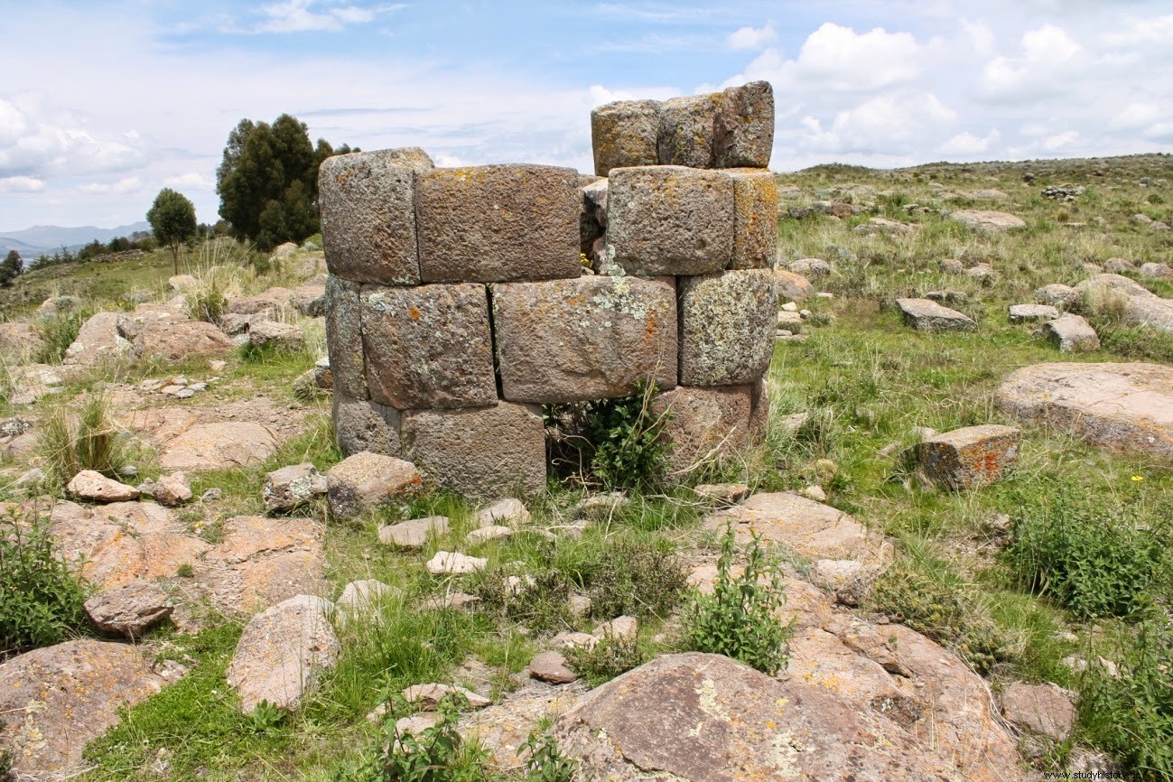 Circular chullpa from Patas community.
 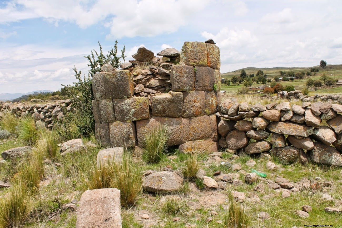 Circular chullpa with Patas snake engraving
 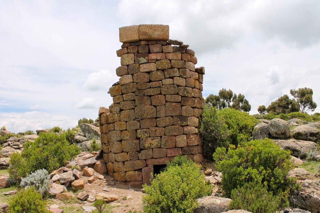 Cacsi Chullpa
 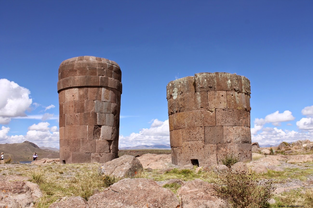 Hatunwasi Chambilla de Sillustani
 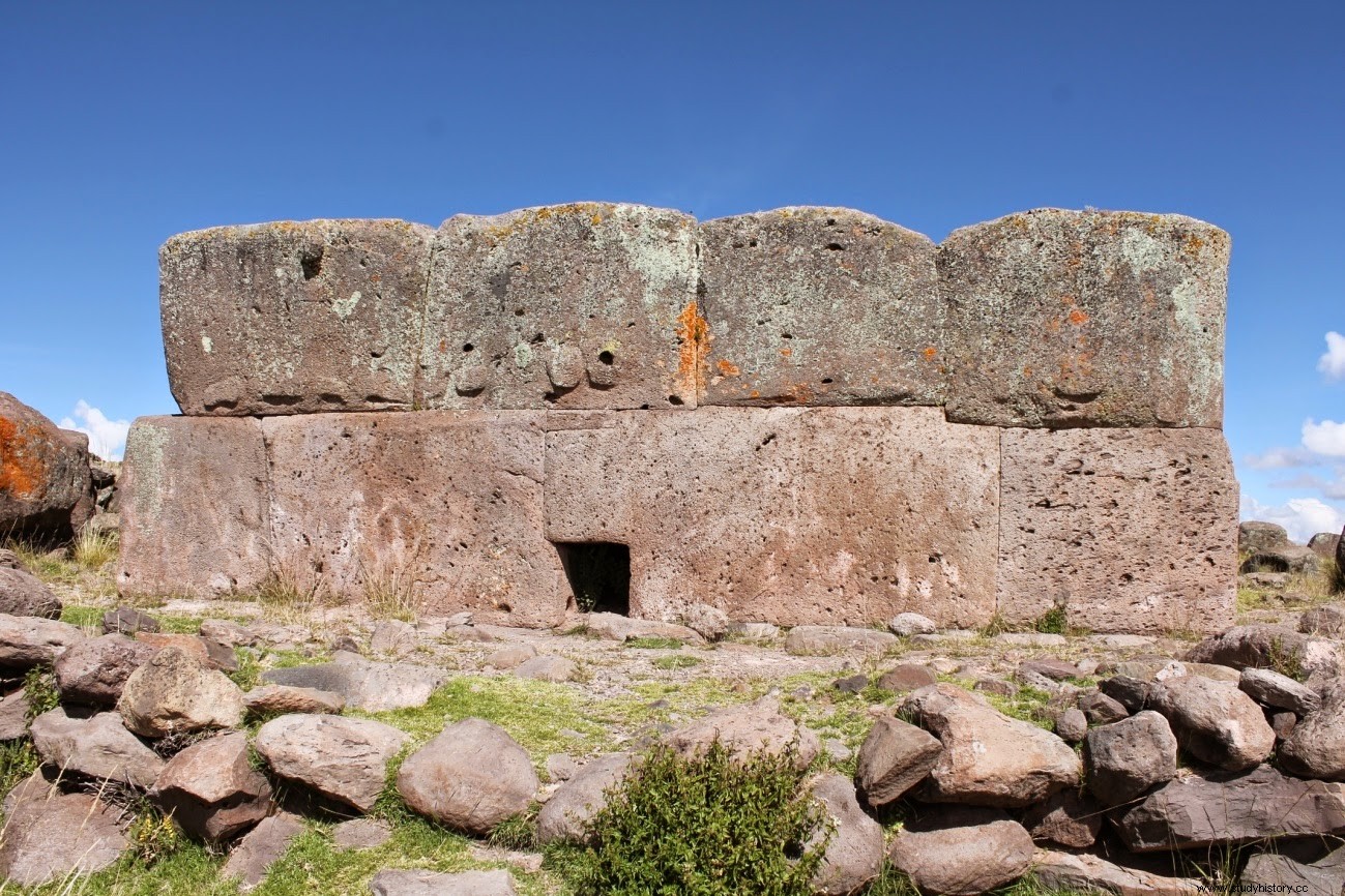 Chullpacuadrada de Sillustani, where the stone with 12 angles can be seen.