Just as in Peru the Nazca Lines have gone from being a mere archaeological monument to becoming an important tourist attraction complementary to Cuzco or Machu Picchu and an economic catalyst for the region, their Bolivian counterparts still remain semi-anonymous, unable to approach the suggestive power of the Salar de Uyuni, the lake Titicaca or any other corner of that beautiful Andean country. Because, in fact, in Bolivia there is something similar to Nazca:the Sajama Lines .
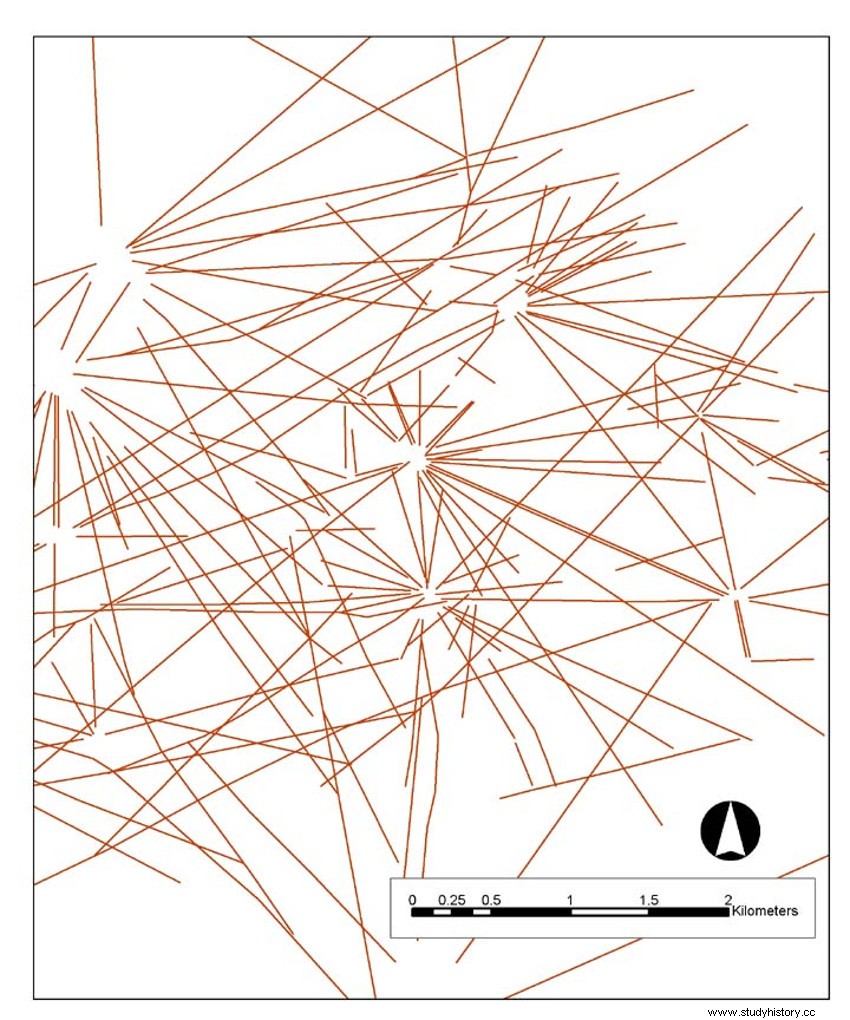
It is a dense network of geoglyphs which extends over an enormous area fifteen times larger than Peru:22,525 square kilometers of the altiplano, in the western extreme of the country, in the vicinity of the Nevado Sajama that gives it its name.
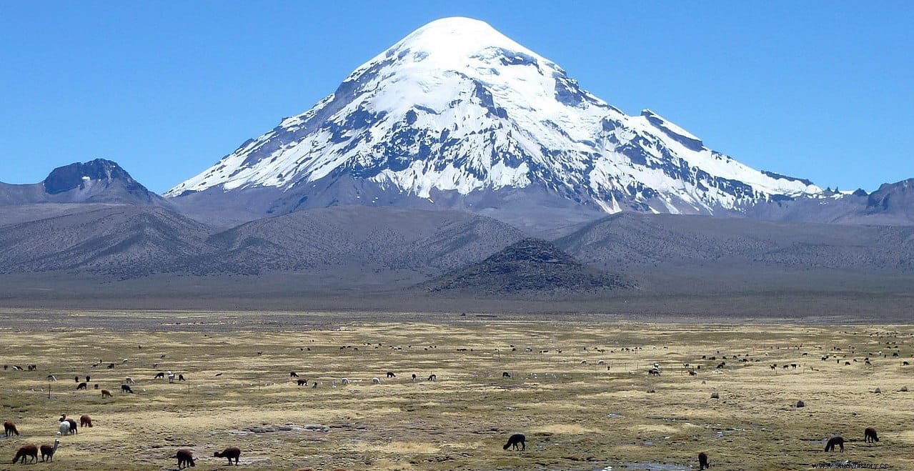
El Sajama, the roof of the country with 6,542 meters of altitude, is an extinct stratovolcano that stands in the department of Oruro, a hundred and a half kilometers from La Paz. The fundamental difference between its lines and those of Nazca is that part of them form drawings that have already become popular, such as those that represent animals (monkey, spider, hummingbird...) or even an anthropomorphic figure, along with many others that are strictly geometric and straight; on the other hand, the Bolivian ones are framed exclusively in this last type.
There are thousands and if you add up its total length it would be around 16,000 kilometers , three times the distance between the East and West coasts of the US.
Each line constitutes a kind of path with a width between 1 and 3 meters , being the longest about 20 kilometers. The construction technique is similar to that of Nazca:removing the vegetation (it is a wooded area) and scraping the dark surface of the ground -basically rusty rock- to expose the next layer , in a lighter shade. The irregularities of the terrain and the natural obstacles typical of the orography of that area add to the lack of perspective to make it difficult to observe the linear development, but clear and impressive views are obtained from the air or from some surrounding mountains.
The people responsible for this great work were the aymara , which is supposed to have carried out the works three millennia ago, although there is currently a small population. However, the Sajama Lines remained anonymous until Aimé Félix Tschiffely , a Swiss nationalized Argentine traveler, made the first reference in his book Paseo de Tschiffely, published in 1932 and in which he recounted the journey he made on horseback from Buenos Aires to New York between 1925 and 1928.
Interestingly, the one who first studied the place was another Swiss, the anthropologist and ethnologist Alfred Métraux , who in 1939 was working in Bolivia with a grant from the Guggenheim Foundation; his work was limited by the short time of his stay, although decades later he would return to South America to focus his interest on Aymaras, Chipayas and Quechuas.
In other words, the Sajama Lines continued in the background from which they have not yet come out, despite the fact that other investigations have been taking place:in the seventies the filmmaker Tony Morrison he shot a documentary and wrote some books on the subject, being the first to suggest the relationship of the lines with the surrounding peaks integrating a kind of pilgrimage complex .
The theory of some Bolivian researchers is oriented towards relating part of the lines to pre-Hispanic necropolises, while other experts do so with important South American spiritual centers (Tihuanaco, Isla del Sol...) or confer an astronomical significance on them.
A few years ago a new study was carried out called Tierra Sajama Project , the result of a collaboration between the University of Pennsylvania and the Landmarks Foundation (a New York non-profit entity dedicated to the conservation of sacred places around the world). Using the most modern technology, such as the GIS satellite system and other digital cartographic means, they created a three-dimensional map of the set of lines and other associated structures with a view not only to trying to expand the information in such a way as to obtain an overview, but also also to favor its adequate protection in the face of a possible and probable tourist exploitation without risk in the future, preparing a management plan to preserve them from both natural (erosion, degradation) and human (vandalism, overcrowding) problems. The project included a fairly complete database, referring to vegetation, surrounding orography, populations, huacas, etc.
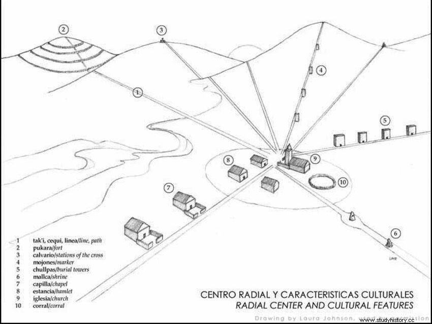
Thanks to the Tierra Sajama Project Some scientists consider that the lines converge at specific points (or start from them) in groups ranging from three to ten, which, combined with other factors (such as the associations indicated above), leads one to think that their construction had a spiritual or religious reason . The American work, however, was harshly criticized and even rejected in its historical part by professional archaeologists, considering it superficial (The authors defended themselves by saying that the press had magnified it).
In fact, many attribute part of the lines to a more recent origin, probably colonial, as mere communication routes . Meanwhile, today the Aymara continue to use them just like that, as paths to get around; they call them ceques . And it is that what could be considered the largest archaeological site in the Andes is still elusive and still keeps many of its secrets.
Fonts
Sajama Land (University of Pennsylvania) / The Sacred Landscape of the Inca. The Cusco Ceque System (Brian S. Bauer) / Apocryphal stories. The other untold story (Carlos Enrique Casero Garcia) / Wikipedia.